File:MonthlyMeanT DEC.jpg
Jump to navigation
Jump to search


No higher resolution available.
MonthlyMeanT_DEC.jpg (550 × 340 pixels, file size: 36 KB, MIME type: image/jpeg)
Captions
Captions
Add a one-line explanation of what this file represents
Summary[edit]
| Description |
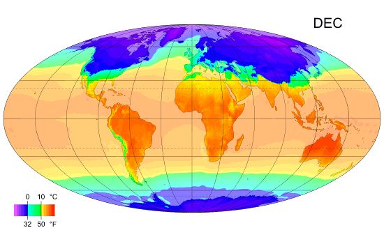
English: Global map of monthly long term mean surface air temperature, December (Mollweide projection). |
| Date | 8 February 2012, 08:13 (UTC) |
| Source |
This file was derived from: MonthlyMeanT.gif: |
| Author | MonthlyMeanT.gif: PZmaps |
| This is a retouched picture, which means that it has been digitally altered from its original version. Modifications: DEC extracted. The original can be viewed here: MonthlyMeanT.gif:
|
Licensing[edit]
I, the copyright holder of this work, hereby publish it under the following licenses:
|
This file is licensed under the Creative Commons Attribution-Share Alike 3.0 Unported license. | |
|

|
Permission is granted to copy, distribute and/or modify this document under the terms of the GNU Free Documentation License, Version 1.2 or any later version published by the Free Software Foundation; with no Invariant Sections, no Front-Cover Texts, and no Back-Cover Texts. A copy of the license is included in the section entitled GNU Free Documentation License. |
You may select the license of your choice.
Original upload log[edit]
This image is a derivative work of the following images:
- File:MonthlyMeanT.gif licensed with Cc-by-sa-3.0, GFDL
- 2009-02-25T12:38:43Z PZmaps 550x340 (414468 Bytes) {{Information |Description={{en|1=Global animated map of monthly long term mean surface air temperature (Mollweide projection).}} |Source=Own work by uploader, sources: [http://www.cru.uea.ac.uk/cru/data/hrg.htm CRU CL 2.0] (
Uploaded with derivativeFX
File history
Click on a date/time to view the file as it appeared at that time.
| Date/Time | Thumbnail | Dimensions | User | Comment | |
|---|---|---|---|---|---|
| current | 08:14, 8 February 2012 | | 550 × 340 (36 KB) | W!B: (talk | contribs) | == {{int:filedesc}} == {{Information |Description={{en|1=Global map of monthly long term mean surface air temperature, December (Mollweide projection).}} |Source={{Derived from|MonthlyMeanT.gif|display=50}} |Date=2012-02-08 08:13 (UTC) |Author=[[:File:Mon |
You cannot overwrite this file.
File usage on Commons
There are no pages that use this file.
File usage on other wikis
The following other wikis use this file:
- Usage on de.wikipedia.org
- Klimatologie
- Frosttag
- Eistag
- Nebeltag
- Vegetationsperiode
- Kalter Tag
- Heißer Tag
- Sommertag
- Schwüle
- Frostzone
- Tagesmitteltemperatur
- Tropennacht
- Schneetag
- Heiztag
- Vorlage:Linkbox Klimatologische Kenntage
- Portal Diskussion:Wetter und Klima/Archiv/2010
- Regentag
- Wüstentag (Meteorologie)
- Heiterer Tag
- Sturmtag
- Gewittertag